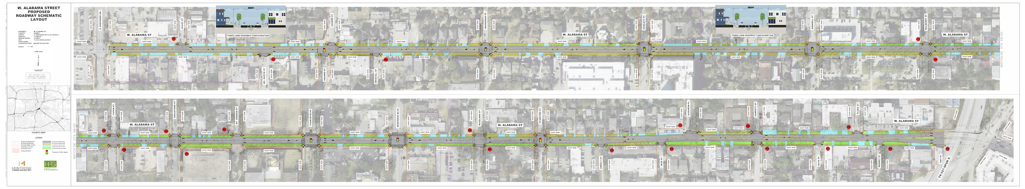
The West Alabama Improvement Project is a planned reconstruction of approximately 1.6 miles of West Alabama Street between Shepherd Drive and Spur 527. The project will address aging pavement, drainage challenges, pedestrian conditions, utilities, signals, and overall corridor functionality while preserving mature trees. This project will connect to West Alabama projects in Midtown and Upper Kirby with similar lane configuration.
West Alabama Street is showing significant deterioration and experiences recurring drainage issues. Sidewalk conditions are inconsistent, inadequate and in poor condition, the center turn lane is unclear in places, and signal infrastructure and utilities are aging. Reconstruction allows these issues to be addressed comprehensively rather than through incremental repairs.
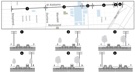
The current roadway consists of three vehicular lanes (two through lanes + one center turn lane) within a roughly 60-foot right-of-way, with sidewalks of varying widths along each side. The project must fit within the existing right-of-way.
No, the lane widths will not increase. The current vehicular lane widths are between 12 and 12.5 feet as shown in the figure below. The proposed lane widths are 11 feet.
A 2023 Johns Hopkins study, https://narrowlanes.americanhealth.jhu.edu/report/JHU-2023-Narrowing-Travel-Lanes-Report.pdf (refer to pages 4 and 79), compared the number of non-intersection crashes at 9-foot vs. 12-foot lanes for roads with 30-35 mph speed limits. Nine-foot lanes have significantly lower crashes than 10-foot, 11-foot or 12-foot lanes, all 3 of which have virtually identical crash rates. However, 9-foot lanes are not contemplated for West Alabama. Reducing the lane width to 9-feet creates problems for emergency vehicles, which are generally 8.5ft wide but with mirrors fully extended can exceed 9 ft. The 11-foot traffic lane width is consistent with typical urban collector street standards that are still expected to allow fire apparatus and ambulances to travel safely through the corridor.
Yes. Comments received from the community at the Open House indicated they fought hard to get the center turn lane and didn’t want to give it up. The 60-foot right of way will allow for two through lanes and one center turning lane. The existing condition is a poorly marked center turn lane. The proposed center turn lane will be better marked, which will increase safety on the roadway. This, along with the narrowed lanes, will increase safety for all roadway users.
Conceptual alternatives that included protected bike lanes were evaluated during early planning, however, with a right-of-way as narrow as 60 feet, there is insufficient space to add bike lanes to two through lanes and one turning lane. In addition, designs incorporating that element are not consistent with current City of Houston mobility and design guidance for this corridor. Also, Montrose’s segment sits between the Upper Kirby and Midtown segments. Since both of those segments do not include bike lanes, our segment should remain consistent with them. As a result, protected bike lanes cannot be incorporated into a design submitted for City approval.
The TIRZ will kick off the Montrose Greenways Planning Study in Winter 2026 to create an off-thoroughfare active transportation connectivity plan.
This corridor is a part of the “GATEWAY SCENIC DISTRICT
https://www.scenichouston.org/post/houston-s-scenic-districts-where-city-life-meets-natural-beauty
https://geogimsprod.houstontx.gov/Html5Viewer/index.html?viewer=Scenic_Districts_ROW
Within the available right-of-way, the project is evaluating a configuration that includes:
- Full concrete roadway reconstruction
- New city-compliant 6-ft sidewalks (reduced as needed for existing trees) with ADA compliant pedestrian ramps
- New street lighting
- New larger storm sewers
- New sanitary sewer and water lines
- New traffic signals will replace all existing traffic signals
- Preserve as many mature trees as possible and add new trees where possible
- New pavement markings (lane lines and crosswalks)
- New traffic light at Hazard
Final design details remain under development.
Approximately 200–300 comments were received through the June 23, 2025, open house and related outreach. Feedback reflected a range of perspectives on corridor priorities, including safety, business access, traffic operations, pedestrian conditions, and multimodal features. Comment summaries and responses are publicly available on the project webpage here https://montrosehtx.org/wp-content/uploads/2025/08/MRA-W-Alabama-06-23-25-Meeting-Comment-Responses.pdf.