
About the Project
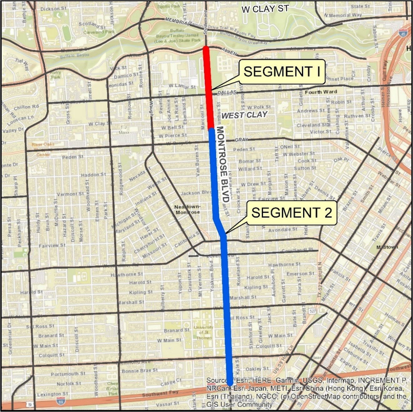
The Montrose Boulevard Improvements Project was designed to address drainage issues while improving mobility, safety, and overall beauty within the beloved Montrose community. Drainage improvements for outdated stormwater infrastructure within the boulevard are long overdue, and the Montrose TIRZ is focusing on Segment 1 (W. Clay Street to Allen Parkway) of the project at this time. Importantly, no planning or design activities have begun related to Segment 2 (US-59 to W. Clay Street) of the project.
Segment 1 of the Montrose Boulevard Improvements Project will:
- Improve drainage, with large underground storm boxes
- Improve roadway mobility and safety for all users
- Promote a pedestrian-friendly environment
- Reconstruct pavement, driveways, medians, and sidewalks
- Replace aging utilities
- Provide greater accessibility to businesses along the boulevard
- Improve intersection safety and upgrade traffic signals
- Replace streetlights to meet requirements
- Protect healthy, well-positioned mature trees
- Plant new trees
- Provide a shared-use path on the east side from W. Clay Street to Allen Parkway, connecting pedestrians, bicyclists, and those with disabilities to trails along Buffalo Bayou
- Provide first- and last-mile bike connections supporting the local and regional “All Ages and Abilities” bike network
It’s About…
Drainage:
Montrose Boulevard serves as the drainage spine for the Montrose area. Through this project, we are working to address drainage issues in problem areas in the vicinity of the project and enhance our long-term capabilities.
Mobility:
We are creating accessibility and comfort for all users by connecting with the east-west biking and walking routes as well as access to Buffalo Bayou Park. We also provide greater accessibility to merchants and restaurants along the Boulevard.
Safety:
As part of the plans, we are creating a buffer with six-foot planting zones behind the curb where we place trees. Additionally, visibility for both pedestrians and vehicles will be enhanced.
Beauty:
We are creating both a healthy tree canopy as well as opportunities for public art. Developing a beautiful natural and created environment has always been important in our Montrose Boulevard redevelopment.
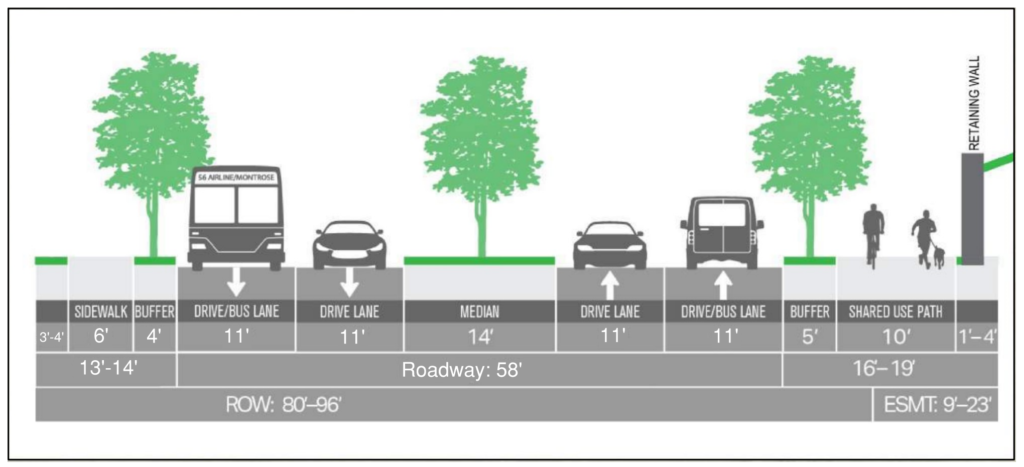
The Montrose TIRZ completed a drainage study in 2019 that highlighted areas of flooding. The project will improve the drainage system by replacing the existing 48-inch and 54-inch pipes with 10-foot by 10-foot boxes. These drainage improvements are designed to accommodate a two-year rainfall event, or five inches in 24 hours, to help mitigate flash flooding in the area and provide five acre-feet of detention.
The project follows all the City of Houston’s design requirements related to drainage, reconstruction of the roadway, upgrade of all the utilities below the roadway, adding the larger safety zone, and providing accessible routes for all while keeping the image of the Boulevard in our goals.
The primary safety facets include the shared-use path and larger sidewalks along with a significant increase in the safety zone between the street and the sidewalk where we will add 137 trees.
Project Status
The Montrose TIRZ has submitted final design plans for Segment 1 (W. Clay Street to Allen Parkway) of the Montrose Boulevard Improvements Project. Approval of final design plans for Segment 1 are currently pending review by the City of Houston.
An anticipated construction timeline for Segment 1 of the project will be determined following review and subsequent approval of the final design plans by the City of Houston. The anticipated cost for Segment 1 is $14.7 million, including the bridge over Allen Parkway to Buffalo Bayou Park.
Segment 2 Update
The Montrose TIRZ has formally withdrawn the Montrose Boulevard Reconstruction (Segment 2) project from consideration through the ongoing Houston-Galveston Area Council (H-GAC) Call for Projects. While we strongly believe the Segment 2 project is a critical, regionally significant, transportation improvement project, we recognize that the distraction created from comments received on the Segment 1 project is absorbing the precious time and attention of a busy and productive body.
Importantly, only preliminary engineering has been completed for Segment 2 of the project (from W. Clay to US-59/IH-69) and the project is still subject to additional detail design efforts to determine specific impacts and mitigations.
The following information provides context related to the public comments recently received.
The public comment received by the Transportation Policy Council has almost entirely been directed at the Segment 1 project, from Allen Parkway to West Clay Street. This project has never been submitted to H-GAC for funding consideration.
We understand there are concerns about impacts to oak trees along the corridor; we have been working over the last year with the community and the city on methods to mitigate impacts and as a result have identified various modifications to the Segment 1 project which would do so. We have provided those options to the City of Houston and are awaiting further feedback to understand what might move forward.
Although we recognize that the Segment 1 project has no functional relationship with H-GAC, we want to clarify that the proposed project will do the following:
- Addresses a designated High Injury Network corridor.
- Rebuilds deteriorated infrastructure.
- Maintains existing vehicular capacity.
- Adds a protected shared use path and sidewalks.
- Adds a protected crossing at West Clay Street to allow for parents and students to safely cross to Wharton Elementary.
- Incorporates a Metro Boost program bus transit enhancement.
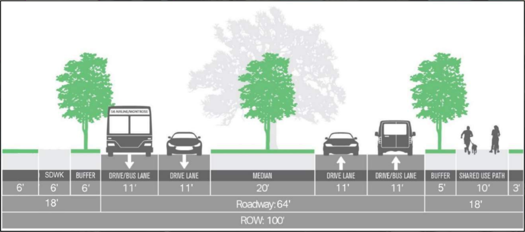
- Provides a foundational drainage corridor to the Montrose area, through providing a storm-sewer trunkline which can serve as the primary south to north conveyance corridor and the outfall for drainage improvements on intersecting east-west streets to reach problem areas within eh community. It is designed to be the primary drainage trunkline for future projects in the community to tie into and will meet 100-year ATLAS 14 drainage criteria.
- The project would beautify the area by installing a wider planting space to enhance future tree growth and will plant 155 trees of 100 to 200 gallons in size, with a four-year watering and maintenance period to protect the investment in vegetation.
Again, we firmly believe in the relevance and importance to the community of this project and greatly appreciate your efforts as we have progressed through the process.
We believe we will ultimately approach H-GAC again after we successfully complete our Segment 1 efforts.
Project Background & Community Engagement
The process to develop the Montrose Boulevard Improvements Project began with a drainage study in 2019 to determine how to improve flooding and drainage within Montrose. Increasing drainage capacity from the existing 48-inch and 54-inch circular pipes to a 10-foot by 10-foot box culvert was the key driver in prioritizing the project, as it can significantly reduce flash flooding during rain events.
Next, a livable centers study was conducted to determine community priorities for infrastructure in the area. This study revealed that the Montrose community desired an improved pedestrian realm to make it easier and safer to walk and bike in Montrose, that prioritized street trees and shade cover, and preserved legacy oaks, particularly along the southern end of the corridor.
Next, the design process began and an initial plan was presented to the public in December 2022. Since then, the Montrose TIRZ has held four public meetings for Segment 1 of the project, solicited community input, and responded to hundreds of questions and concerns from the community.
The Montrose TIRZ has carefully considered and incorporated several improvements to the project design as a result. The feedback received to date has addressed several topics of concern, including pedestrian safety, tree preservation / maintaining a shaded pedestrian realm, and bicycle facilities. As a result, the Montrose TIRZ has incorporated the following elements into the project design while striving to achieve a balanced design approach:
- A 10-foot-wide shared use path
- Improved pedestrian safety for signalized and closed median intersections
- Opportunities to incorporate public art
- Preservation of many healthy trees and additional tree plantings along the project corridor